
Christians in GIS
Background and Purpose. Christians in GIS is a community dedicated to fostering fellowship and collaboration among individuals who share both a passion for Geographic Information Read More …
We love God, people, and GIS

Connect and share with other Christ followers working in GIS
Background and Purpose. Christians in GIS is a community dedicated to fostering fellowship and collaboration among individuals who share both a passion for Geographic Information Read More …
Our identity as followers of Jesus can and should transform how we live in the physical world. We need a far more expansive Christian imagination Read More …
For those of you attending the Esri User Conference July 14 – 18, we are meeting during lunch time, Monday, July 14 at 12:30 PM. Read More …

By Frank Roberts When I became a Christian over thirty years ago, I was excited to see the way God would use me. As I Read More …
In this webinar, Dr Girju (professor of marketing and analytics) and her students, will present a series of hands-on, experiential studies in spatial analytics in Read More …
We welcome Christians and anyone willing to respect the guiding principles of this group reflected in the Apostles Creed. Let’s meet and have lunch together. Find Read More …
Exploring God’s Creation, One Map at a Time. That’s been my goal while hand drawing maps for over a decade now. And in a greater Read More …
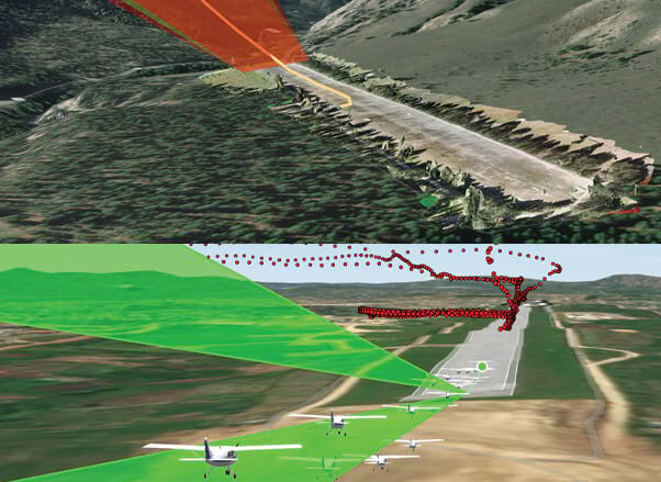
(Repost) Mission Aviation Fellowship (MAF) is a Christian mission-based organization that has been using small aircraft for 80 years to provide help, hope and healing Read More …
Hurricane Helene, a category 4 hurricane that came ashore late on September 26th in the Big Bend region of Florida, became an overwhelming tropical storm Read More …
Explore how data analytics tools play a crucial role in humanitarian emergency response. We’ll delve into topics such as satellite imagery, damage assessment models, and Read More …